|
This short article suggests a causative relationship between lineaments and fractures in oil fields of the Great Basin. Because the lineaments are definable with regional gravity and magnetic data, they may be used as a predictive tool to delineate analogs to the existing production.
RELATIONSHIP BETWEEN HYDROCARBON PRODUCTION AND LINEAR GEOPHYSICAL DISRUPTIONS, RAILROAD VALLEY, NEVADA
by
Richard I. Gibson
Gibson Consulting
301 N. Crystal St.
Butte, Montana 59701
E-Mail
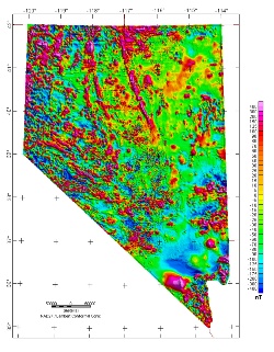 | | Nevada magnetic map from USGS |
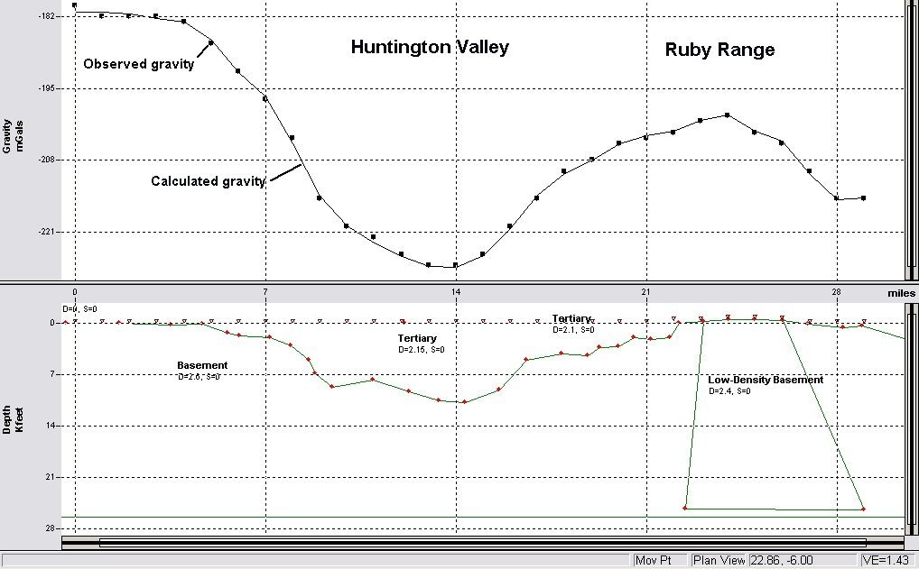
Gravity anomalies have been shown to have a direct relationship to the general locations of oil fields in Railroad Valley, Nevada (Guion and Pearson, 1979, RMAG Guidebook). Gravity gradients mark the density contrast between Tertiary valley fill and pre-Tertiary rocks, thus defining normal faults. In many cases, such faults do not reach the surface and do not coincide with range-front faults. While the basin-range normal faults are important contributors to the hydrocarbon traps in Railroad Valley, the oil accumulations are more complex and are related to other structural and stratigraphic features.
Guion and Pearson (1979) pointed out that Eagle Springs Field is in a gravity "embayment" or low, bounded on the south by a small ridge in Paleozoic rocks and on the east by two normal faults. The southern margin of the embayment is a subtle east-west linear feature visible in magnetic data and possibly in gravity data as well (Nev. BuMines, 1983).
Lineaments have long been related to structures and regional features in Nevada. Rowan and Wetlaufer (1981, AAPG Bull., Aug.) described lineaments as parts of three broad structural zones. In my study, five linear features are correlated with the locations and geometries of all the hydrocarbon production to date in Railroad Valley.
Linear disruptions in east-central Nevada were identified initially on maps of magnetic data (USGS MF-902); many had been defined earlier by Ekren and others (1976, USGS Prof. Pap. 986). Most of the grabens in this part of Nevada are segmented along their lengths, and are expressed as chains of sub-circular to oval gravity lows separated by high saddles. When the linear features defined from magnetics were compared to gravity maps, it was found that many of them corresponded with the gravity high saddles that segment the grabens.
The linear geophysical features have abundant surficial geological expression and are also evident in Landsat images. Rowan and Wetlaufer have summarized this evidence for the lineaments they described. In many cases, these features also coincide with marked excursions in the boundaries of playa deposits and the dog-leg geometry of range-front faults as mapped by Stewart and Carson (1978, Geol. Map of Nevada).
Portions of five regional lineaments are shown on Figure 1, with gravity data from Nevada Bureau of Mines and Geology. The three east-west features, from south to north, are 1) the Warm Springs Lineament, somewhat north of the feature defined by Ekren and others (1976); 2) an extension of the Pancake Range Lineament; and 3) a lineament that passes near the town of Currant.
The NE-SW linear is one of several that are well expressed in magnetic data, especially northeast of Ely; it is marked by a subtle but clear gravity anomaly (Guion & Pearson, 1979, Fig. 10). The NW-SE lineament is the extension of the Northern Nevada Rift of Zoback and Thompson (1978; Geology Vol. 6, p. 111) (Oregon Nevada Lineament of Stewart and others, 1975, Geology). The magnetic expression of the latter lineament is much weaker in the area of Railroad Valley than in areas to the northwest, where the magnetic anomalies are related to a linear mafic dike swarm (Zoback and Thompson, 1978). Rocks similar to the surficial rocks corresponding to the strongest magnetic anomalies are mapped as basalt and andesite flows. These rocks crop out along the lineament from the Idaho border to Kobeh Valley, and in isolated small outcrops in the Grant Range and White River Valley, just southeast of Railroad Valley.
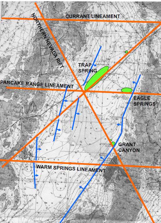 The five lineaments described above affect Railroad Valley in different ways. The Warm Springs Lineament strongly segments the graben, separating two gravity lows at a saddle whose value is almost 25 milligals higher than the lowest low in the central part of the northern sub-graben. The Pancake Range lineament affects the gravity only slightly; north of the line the gravity low is about 0.5 miles wider than it is to the south. The Currant Lineament marks the northern limit of the deep Railroad Valley graben. The NE-SW lineament has the subtle gravity expression noted above, and also appears to truncate three step-like normal faults which form the asymmetrical west side of the graben.
The main graben fault on the east side of Railroad Valley does not coincide with the range front fault mapped by Stewart and Carson (1978). The gravity data clearly indicate that the strongest density contrast, interpreted as a fault with significant throw, is west of the range front by a distance which varies from a fraction of a mile at Eagle Springs Field to about three miles along the Warm Springs lineament.
The linear features appear to be related to the orientations of the fields in the Valley. Eagle Springs field is elongate perpendicular to the graben-bounding normal fault, but is parallel to the Pancake Range Lineament. Trap Spring Field trends along the NE-SW lineament, though the easternmost of the normal faults on the west side of the valley is an important factor in the trap. Production at tiny Currant Field is located along the NE-SW feature, while the pools at Bacon Flat and Grant Canyon are at the intersection between the lineament extending SE from the Northern Nevada Rift and the main eastern graben fault.
 I postulate that the regional linear features are persistent weak zones whose reactivation through time has enabled hydrocarbons to accumulate, because of the creation of subtle structures and trapping mechanisms. It is also likely that movement along the linear features helped generate fracture porosity in the reservoir rocks, accounting for the anomalous elongation of Eagle Springs and Trap Spring Fields. The inferred slump blocks of reservoir rock at Grant Canyon-Bacon Flat are suggested to have been localized by the intersection of the NNW-trending weak zone with the graben fault. Similar circumstances abound in east-central Nevada and can be identified through detailed regional analysis of gravity and magnetic data. The resulting tectonic interpretation should then be applied locally to generate specific prospects in conjunction with local geologic, geochemical, imagery, and seismic studies. I postulate that the regional linear features are persistent weak zones whose reactivation through time has enabled hydrocarbons to accumulate, because of the creation of subtle structures and trapping mechanisms. It is also likely that movement along the linear features helped generate fracture porosity in the reservoir rocks, accounting for the anomalous elongation of Eagle Springs and Trap Spring Fields. The inferred slump blocks of reservoir rock at Grant Canyon-Bacon Flat are suggested to have been localized by the intersection of the NNW-trending weak zone with the graben fault. Similar circumstances abound in east-central Nevada and can be identified through detailed regional analysis of gravity and magnetic data. The resulting tectonic interpretation should then be applied locally to generate specific prospects in conjunction with local geologic, geochemical, imagery, and seismic studies.
On the basis of this approach, the location of Grant Canyon-Bacon Flat was recommended in 1979 as an analog to Eagle Springs and Trap Springs Fields; Bacon Flat was discovered in 1981 and the prolific Grant Canyon field was found in 1983-84, both by companies that I did not work for and had not made the recommendation to.
|