Hike to the Humbug Spires
Text and photos by Dick Gibson
October 1999
Canine comments by Cody (R.I.P.; 1998-2011)

 The day promised to be a near-record warm day, and with hunting season just around the corner, Cody and I left the Field Station for a day hike into the Humbug Spires Primitive Area south of Butte, Montana. We left Interstate 15 in the dry, treeless basin just south of the Continental Divide, and headed up Moose Creek. Three miles up a good gravel road (with occasional big-time washboard), we stopped at the trailhead and set out. The day promised to be a near-record warm day, and with hunting season just around the corner, Cody and I left the Field Station for a day hike into the Humbug Spires Primitive Area south of Butte, Montana. We left Interstate 15 in the dry, treeless basin just south of the Continental Divide, and headed up Moose Creek. Three miles up a good gravel road (with occasional big-time washboard), we stopped at the trailhead and set out.
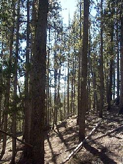
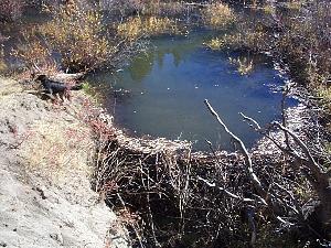 The trail gently ascends the west bank of Moose Creek, passing a sequence of 8 or 10 beaver dams. The ponds behind the dams were frozen over in places, even on a sunny, 60° morning in late October -- and melted enough on our return for Cody to learn the meaning of "thin ice." After about a mile of forest walking along the stream, we left the creek and climbed step-like notches in the white granite, plunging into the silence of a warm, breezeless, unpeopled pine woods. For about a half-mile, the trail was noticeably steeper, but then it suddenly crested a rise and began to follow a wide boggy zone of very low gradient. The tiny rivulet here was on the surface in some places and under rocks and moss in others, gurgling its way down to join Moose Creek. The trail gently ascends the west bank of Moose Creek, passing a sequence of 8 or 10 beaver dams. The ponds behind the dams were frozen over in places, even on a sunny, 60° morning in late October -- and melted enough on our return for Cody to learn the meaning of "thin ice." After about a mile of forest walking along the stream, we left the creek and climbed step-like notches in the white granite, plunging into the silence of a warm, breezeless, unpeopled pine woods. For about a half-mile, the trail was noticeably steeper, but then it suddenly crested a rise and began to follow a wide boggy zone of very low gradient. The tiny rivulet here was on the surface in some places and under rocks and moss in others, gurgling its way down to join Moose Creek.
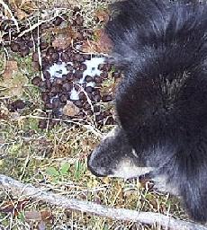 The forest animal life showed itself rarely, as Cody spied and chased several squirrels. Apart from a collection of raucous Clark's nutcrackers near the trailhead, the squirrels were the only vertebrates we saw. However, Cody was thoroughly occupied as a professional scatologist, collecting information for his database of smells. We saw horse, dog, bear, deer, and elk droppings for sure, maybe moose, and some unidentifiable things that Cody was very interested in. Mountain lions and bobcats have been seen -- but not by us. Few insects have survived all the cold nights, and the grasses and forbs were mostly brown and dry, with occasional green color remaining on ground-hugging plants. We did not notice any fish in the creeks, although small (10" and less) brook, rainbow, and cutthroat trout are reported. The forest animal life showed itself rarely, as Cody spied and chased several squirrels. Apart from a collection of raucous Clark's nutcrackers near the trailhead, the squirrels were the only vertebrates we saw. However, Cody was thoroughly occupied as a professional scatologist, collecting information for his database of smells. We saw horse, dog, bear, deer, and elk droppings for sure, maybe moose, and some unidentifiable things that Cody was very interested in. Mountain lions and bobcats have been seen -- but not by us. Few insects have survived all the cold nights, and the grasses and forbs were mostly brown and dry, with occasional green color remaining on ground-hugging plants. We did not notice any fish in the creeks, although small (10" and less) brook, rainbow, and cutthroat trout are reported.
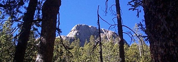
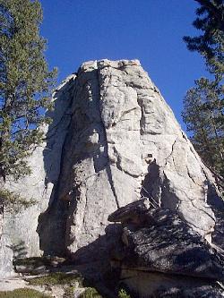
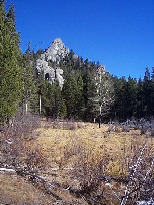 Eventually, the first of the spires was revealed along the length of the wide, open meadow bordering the boggy creek. These massive outcrops are granitic, probably a satellite pluton of the Butte Quartz Monzonite, which itself is one of the main intrusives of the ±70-million-year-old Boulder Batholith. The aspect of the rocks here is different from that displayed along the interstate near Butte, where the rocks weather to a brownish color. Here, fresh white gives way to weathered light gray, not that different from the fresh surfaces. It appears to be essentially a quartz-feldspar rock, with very minor dark minerals. The background of this page is a slightly lightened photograph of a rock face in the sun. Also, the physical character of these outcrops is somewhat different from the Batholith around Butte, where spheroidal weathering along close but unequally spaced joints produces rounded rectangular boulders and narrow fin-like ridges. Possibly the jointing is the primary difference, with joints on a wider scale here at the Spires, but since this does appear to be a distinct pluton, there may be rock chemical or mineralogical differences as well. Eventually, the first of the spires was revealed along the length of the wide, open meadow bordering the boggy creek. These massive outcrops are granitic, probably a satellite pluton of the Butte Quartz Monzonite, which itself is one of the main intrusives of the ±70-million-year-old Boulder Batholith. The aspect of the rocks here is different from that displayed along the interstate near Butte, where the rocks weather to a brownish color. Here, fresh white gives way to weathered light gray, not that different from the fresh surfaces. It appears to be essentially a quartz-feldspar rock, with very minor dark minerals. The background of this page is a slightly lightened photograph of a rock face in the sun. Also, the physical character of these outcrops is somewhat different from the Batholith around Butte, where spheroidal weathering along close but unequally spaced joints produces rounded rectangular boulders and narrow fin-like ridges. Possibly the jointing is the primary difference, with joints on a wider scale here at the Spires, but since this does appear to be a distinct pluton, there may be rock chemical or mineralogical differences as well.
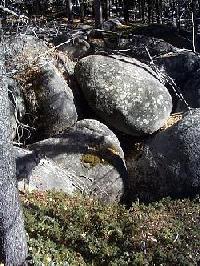
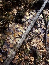
 We are not too far from the pluton margin, as shown by rare xenoliths; both Proterozoic Belt and Archean metamorphics are found in the southern Highland Range, no more than 3 or 4 miles south of the Spires. This igneous body is probably the southwesternmost pluton of the Boulder Batholith (pink on the 1955 Geologic Map of Montana, shown here), separated from the main mass to the north by a roof pendant or remnant of Phanerozoic sedimentary rocks. Nearly the entire section from Cambrian to Cretaceous is shown (orange and blue on the map) north and east of the Spires Pluton. These strata are probably contact-metamorphosed, and Mt. Humbug, a couple miles northeast of the Spires in Paleozoic carbonates, is dotted with mines and prospects. Most of the soil in the Spires area is grus, a coarse sand or gravel consisting of the broken-down granitic rock. But there are plenty of pine needles covering the rock fragments in many places -- this forest is predominantly Douglas fir and Ponderosa pine, and in most places is moderately dense, with some trees upwards of 250 years old. The stands of aspen that are present are rather small, concentrated along the banks of the streams with willows and dogwoods and other riparian species. The boggy meadows consist primarily of grasses and mosses. We are not too far from the pluton margin, as shown by rare xenoliths; both Proterozoic Belt and Archean metamorphics are found in the southern Highland Range, no more than 3 or 4 miles south of the Spires. This igneous body is probably the southwesternmost pluton of the Boulder Batholith (pink on the 1955 Geologic Map of Montana, shown here), separated from the main mass to the north by a roof pendant or remnant of Phanerozoic sedimentary rocks. Nearly the entire section from Cambrian to Cretaceous is shown (orange and blue on the map) north and east of the Spires Pluton. These strata are probably contact-metamorphosed, and Mt. Humbug, a couple miles northeast of the Spires in Paleozoic carbonates, is dotted with mines and prospects. Most of the soil in the Spires area is grus, a coarse sand or gravel consisting of the broken-down granitic rock. But there are plenty of pine needles covering the rock fragments in many places -- this forest is predominantly Douglas fir and Ponderosa pine, and in most places is moderately dense, with some trees upwards of 250 years old. The stands of aspen that are present are rather small, concentrated along the banks of the streams with willows and dogwoods and other riparian species. The boggy meadows consist primarily of grasses and mosses.
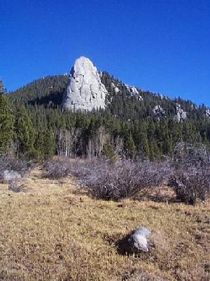  A short, steep climb took us through an immense boulder zone that separates the lower part of the boggy creek from a very similar reach perhaps 150 feet higher. Soon, higher spires were visible in the distance. The white monoliths tower unexpectedly over the pines, like Mayan pyramids above the jungle. The scale is different, but these granitic domes are highly reminiscent of the exfoliation domes in Yosemite National Park. A short, steep climb took us through an immense boulder zone that separates the lower part of the boggy creek from a very similar reach perhaps 150 feet higher. Soon, higher spires were visible in the distance. The white monoliths tower unexpectedly over the pines, like Mayan pyramids above the jungle. The scale is different, but these granitic domes are highly reminiscent of the exfoliation domes in Yosemite National Park.
 As we climbed slowly higher, from our starting elevation of 5800 feet to a high point about 6800 feet, deeply shadowed reaches of the boggy creek held patchy remnants of last weekend's snowfall, and some parts of the little creek were frozen over. Surprisingly, the snow seemed to be preferentially preserved where it lay on piles of horse manure! On the high saddles on the way up, and in the higher areas of the hike later in the day, gentle winds were in the pines, providing a bit of soft white noise. The light breeze, as it quakes the aspen that are not yet completely bare, is much more of an attention-getter than the wind's soft pulsing through the pine needles. It's surprising that such sere leaves can stay attached. Most have not, and lie on the trail and in the creek beneath the aspen groves. As we climbed slowly higher, from our starting elevation of 5800 feet to a high point about 6800 feet, deeply shadowed reaches of the boggy creek held patchy remnants of last weekend's snowfall, and some parts of the little creek were frozen over. Surprisingly, the snow seemed to be preferentially preserved where it lay on piles of horse manure! On the high saddles on the way up, and in the higher areas of the hike later in the day, gentle winds were in the pines, providing a bit of soft white noise. The light breeze, as it quakes the aspen that are not yet completely bare, is much more of an attention-getter than the wind's soft pulsing through the pine needles. It's surprising that such sere leaves can stay attached. Most have not, and lie on the trail and in the creek beneath the aspen groves.
There are more than 50 high spires in the area, including nine that rise from 300 to 600 feet above the surrounding terrain. We got close to 4 of them, as well as elongate, high ridges of granite. The knobs are visible from the Interstate, and this must be one of the closest primitive areas to a 4-lane highway in the U.S. It is not a designated wilderness; the BLM manages it as a wilderness study area.
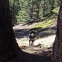 Cody sets a mighty pace. His standard procedure is to sprint about 200 feet ahead, and if he has not encountered anything interesting to investigate, he invariably stops and looks back up the trail to see if I am coming. As I plod into view, he takes about three seconds for a positive I.D., and then he's off again. If I'm too slow, he comes running back up the trail until he finds me. It's pretty cool to see his face framed between the trees or bushes as he verifies that I have not tricked him and headed off some other way. He does not have much of a problem being behind me momentarily, since he knows he can pass me in seconds like a diesel locomotive compared to a mule train. He ran virtually all the time, obviously for the joy of it, just as he does around the Field Station. Cody sets a mighty pace. His standard procedure is to sprint about 200 feet ahead, and if he has not encountered anything interesting to investigate, he invariably stops and looks back up the trail to see if I am coming. As I plod into view, he takes about three seconds for a positive I.D., and then he's off again. If I'm too slow, he comes running back up the trail until he finds me. It's pretty cool to see his face framed between the trees or bushes as he verifies that I have not tricked him and headed off some other way. He does not have much of a problem being behind me momentarily, since he knows he can pass me in seconds like a diesel locomotive compared to a mule train. He ran virtually all the time, obviously for the joy of it, just as he does around the Field Station.
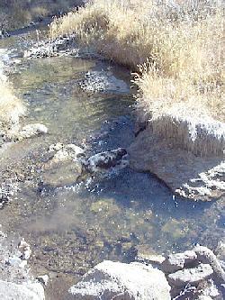 On the return trip, we crested a final rise and could immediately hear the tumult of Moose Creek below. After the silence of the upper forest, it was like the roar of a thousand Niagaras, although Moose Creek is just about the same size as the South Boulder at the Field Station. Cody liked it better, because it had a more sandy stream bed in many places, compared to the slippery boulders of the South Boulder. On the return trip, we crested a final rise and could immediately hear the tumult of Moose Creek below. After the silence of the upper forest, it was like the roar of a thousand Niagaras, although Moose Creek is just about the same size as the South Boulder at the Field Station. Cody liked it better, because it had a more sandy stream bed in many places, compared to the slippery boulders of the South Boulder.
The leisurely 4-hour hike totaled about 5˝ miles round trip, with an elevation gain of about 1000 feet. We had the entire primitive area to ourselves on this late October Friday, and it was in the upper 60s most of the day, with a typical (but nonetheless wonderful) Montana blue sky. It was both a mental and a physical rejuvenation -- and Cody actually acted tired that evening for about the third time since he's been here -- but then he probably ran twice as far as I walked!
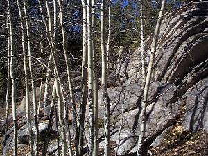 | | 
Left: Aspen trunks and granite; right: Humbug granite.
How glorious a greeting the sun gives the mountains!
To behold this alone is worth the pains of any excursion a thousand times over.
-- John Muir
Back to Expeditions Page
|