The Greater Green River Basin has a long history of oil and gas exploration and production, and today this area is attracting considerable attention as one of the nation's most important producers of natural gas.
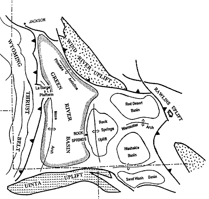
The Greater Green River Basin is a complex of depressions separated by uplifts and ridges, primarily in southwestern Wyoming, but extending into Utah and Colorado. Included are the Green River, Red Desert (or Great Divide), Washakie, and Sand Wash Basins, with major bounding features in the Wind River, Rawlins, Sierra Madre, and Uinta Uplifts. Each uplift brings crystalline Precambrian basement rocks to the surface, and smaller ridges such as the Rock Springs Uplift, Wamsutter Arch, and Moxa Arch are broad, relatively deep-seated highs that warp the basement as well as the overlying sedimentary rocks. The west side of the Green River Basin is bounded by the Wyoming-Utah-Idaho Overthrust Belt, in which sedimentary rocks have been pushed up and over the western margin of the basin. The total sediment thickness in the basins is variable, but is as much as 32,000 feet in the northern Green River Basin.
Most of the reservoirs are sandstones, and the most important strata are numerous layers of Cretaceous age. About 6000 billion cubic feet (Bcf) of gas has been produced from Cretaceous beds, while only 1600 Bcf has come from all other formations combined. The Greater Green River Basin contains more than 100 fields with more than 1 million barrels of oil equivalent (MMBOE).
The petroleum geology of the Green River Basin area reflects its geologic history. For much of Paleozoic time (Cambrian through Permian, about 570 to 240 million years ago), the Rocky Mountain region was part of a submarine continental shelf on the western flank of North America. Relatively quiet, shallow seas were the sites of deposition of fine sediments such as shales, together with abundant limestones. Although limestones can be quite porous, in the Green River Basin area they do not form significant reservoirs for oil and gas. In fact, much of the gas that is found in Mississippian-age carbonates is CO2, probably generated by heating up of the calcium carbonate that forms the limestone. Some of this non-flammable gas may be used in enhanced recovery projects in the region in the future, but otherwise markets for CO2 are limited. Some relatively minor oil and gas production comes from Pennsylvanian (Amsden and Weber Formations), Permian (Phosphoria), and Early Jurassic (Nugget) strata in the Green River Basin area, together with a few other formations. The Phosphoria Formation and Cretaceous Mowry Shale are thought to be the primary source rocks for the Greater Green River Basin oil and gas.
By Late Jurassic time (about 170 million years ago), the tectonic framework of western North America was changing. Continental plate motions were bringing the margin of the continent near a complex volcanic island arc (somewhat like modern-day Japan) at the start of the Sevier Orogeny. Sediments derived from this western source, together with the first thrust faults that resulted from collision with North America, put a great load on the edge of the continental crust, bowing it down. This permitted the deposition of more and more sediments, in a classic foreland basin of Cretaceous age (140-65 million years ago). Sediments were shed off the rapidly rising western upland, and were carried eastward by complex braided streams toward a shallow sea in the Great Plains. These river systems laid down many of the sand bodies that are among the best hydrocarbon reservoirs today, including rocks in the Morrison, Cloverly, and Dakota (or Muddy) intervals.
Fluctuating shorelines, reflecting transgression and regression of the eastern sea, were the sites of deposition of beach sands, deltas, and near-shore bars, which also make excellent reservoirs. The Frontier Formation, which can be more than 1,100 feet thick in the western Green River Basin, is a predominantly beach and delta deposit related to varying sea levels.
Following deposition of the Frontier Formation, the region saw continued development of non-marine fluvial (river) systems and some marginal marine environments. These thick sections include the Mesaverde Group (with the Almond Sandstone at the top) and the Lewis, Lance, and Fox Hills Formations. Many of the units have excellent reservoir qualities, including porosities of 5-20% in the Dakota and Frontier sands, and permeabilities up to several hundred millidarcies. Permeability may be enhanced by natural or artificial fracturing. One drawback is that sands laid down in river channels tend to be long, narrow bodies that are often lenticular in cross-section, but when they are stacked, they can form a thick reservoir sequence.
Toward the end of the Cretaceous and continuing for several million years after its end, the foreland basin began to be segmented by huge basement block uplifts - the modern Wind River and Uinta Uplifts, and others throughout the Northern Rocky Mountain Region. This mountain-building event is usually called the Laramide Orogeny, and its ultimate cause is still the subject of some controversy. Warren Hamilton of the US Geological Survey suggested that it may reflect rotation of the Colorado Plateau block against the western margin of North America, breaking the Wyoming Foreland region. The uplifts cut off the sediment supply from the west, but they provided a significant local source of sediments. Deposits associated with these uplifts (Fort Union and Wasatch Formations) are as much as 10,000 feet thick in places, and they do contain some oil and gas.
The first gas was discovered in the basin in 1922 at South Baxter Basin, on the Rock Springs Uplift. In the Green River Basin itself, the most prolific production comes from the La Barge Platform (including Big Piney Field), which has produced more than 80 million barrels of oil and has an estimated ultimate recovery of more than two trillion cubic feet (Tcf) of gas. Production is from essentially all of the potential producing horizons, and although the field was discovered in 1924, most of the development occurred in the 1970s and 1980s. Moxa Arch fields produce mostly from the Frontier Formation, and together contain more than one Tcf of gas (estimated ultimate recovery) in the Frontier and other strata. The Moxa Arch-La Barge Platform area is a broad, deep-seated basement uplift with drape of sediments over it, resulting in large closure and large oil and gas pools. The traps are really combination structure and stratigraphic traps, because the reservoir depends on the nature of the rocks as well as the structural arching.
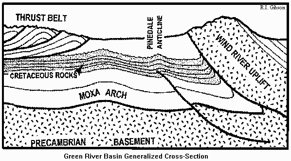
Pinedale Field, on the northeast flank of the northern Green River Basin, was never a great producer, but it is interesting as a relatively large structural closure. This anticline is probably a drape over a small basement fault related to the much larger Wind River Uplift. The low angle of throw on the Wind River Fault (and others in the Wyoming Foreland Province) led to a sub-upthrust play in the early 1980s. Denver geologist Robbie Gries and others studied many of the mountain fronts to suggest possibilities of hydrocarbon entrapment in a play that required drilling though thousands of feet of Precambrian granite and metamorphic rocks in the overhanging portions of the upthrusts. No production in the sub-upthrust play has been established, but it is very immaturely explored.
One of the US Geological Survey's unconventional plays in this area is the deep basin-centered tight gas play. Sources are the coal and carbonaceous shale in the Cretaceous Cloverly, Frontier, and Mowry Formations, and potential sandstone reservoirs exist in both the Cloverly and Frontier. This play has seen active drilling recently, especially in the Moxa Arch. The play extends to the Mesaverde group, where it is focused on the Almond Formation. Sweet spots in the Almond offer better reservoir quality than other parts of the Mesaverde, and may serve as good targets for horizontal drilling. Throughout these deep-basin rocks, fracture porosity is critical to accumulation, and artificial hydraulic fracturing is commonly used to improve production rates. However, horizontal drilling may be more appropriate where artificial fractures are parallel to natural fractures or where other limiting factors exist for conventional hydrofracturing. More efficient methods of detecting natural fractures are also needed, and may include combinations of remote sensing, regional gravity and magnetics, and specialized seismic studies. The USGS in 1995 predicted that "it is likely that at least one accumulation larger than 1 MM BOE will be discovered" in the Mesaverde tight gas play.
The Green River Basin Advisory Committee of the Department of the Interior recommended to former Interior Secretary Bruce Babbitt that operators should be given relief from costs associated with compliance with the National Environmental Policy Act, and that the required environmental analysis process should be streamlined. This may help stimulate an area that is already seeing active exploration and development programs.
|