Grand Canyon Hike
by Dick Gibson

This article first appeared in the September-October 1987 issue of
Great Expeditions Adventure and
Travel Magazine.
 Forty- and fifty-mile-per-hour gusts
buffeted us as we rigged for a rappel through a 70-foot section of
the Coconino Sandstone. Pebbles and occasional rocks the size of your
fist came down like bullets, blown from the cliffs above. Even with
backpacks on, we felt that the wind was about to blow us off the ledges,
onto the rocks 100 feet below. It was our second use of ropes on the
first day of a 6-day hiking trip in the western Grand Canyon. Forty- and fifty-mile-per-hour gusts
buffeted us as we rigged for a rappel through a 70-foot section of
the Coconino Sandstone. Pebbles and occasional rocks the size of your
fist came down like bullets, blown from the cliffs above. Even with
backpacks on, we felt that the wind was about to blow us off the ledges,
onto the rocks 100 feet below. It was our second use of ropes on the
first day of a 6-day hiking trip in the western Grand Canyon.
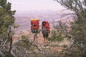
Terry and Lynda Cox, Ted Petranoff, Bill Dorrance and I were descending a little-traveled route which
drops off the canyon rim near Point Huitzil. The starting point was 22 miles by dirt road from Grand
Canyon Village on the south rim, and two more miles of bushwhacking to the rim itself. A "route," as
distinct from a trail, is a known way of getting from one point to another. Terry and Ted, experienced
Canyon hikers with more than 12 annual expeditions, had gone this way before, so the main problem was
finding the exact way. Cairns mark the route in many places, but often you just pick the best -- or only
possible -- way.
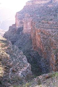
 The first use of ropes had come in the upper Coconino Sandstone, a massive cliff-forming unit which is
usually hard to get through. After picking our way downward, we came to a place where it looks like the
route goes over an impossible dropoff -- you see nothing but air. We were belayed as we slid on our
behinds down the smooth foreset of one of the crossbeds in the sandstone, to a small hole, where, with a
lot of faith and encouragement, you can step down on a nearly invisible rock and into an adult-sized crack
behind a huge fallen block. The first use of ropes had come in the upper Coconino Sandstone, a massive cliff-forming unit which is
usually hard to get through. After picking our way downward, we came to a place where it looks like the
route goes over an impossible dropoff -- you see nothing but air. We were belayed as we slid on our
behinds down the smooth foreset of one of the crossbeds in the sandstone, to a small hole, where, with a
lot of faith and encouragement, you can step down on a nearly invisible rock and into an adult-sized crack
behind a huge fallen block.
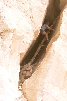
After snaking through this crack, you encounter a steep fall of perhaps 12 feet, which was jammed with a
tree trunk by the Anasazi, the Native Americans who lived in this area, to serve as a ladder. Dates from
other parts of the canyon indicate that the Anasazi left this area about 1150 A.D., so the tree trunk we
were climbing on was over 800 years old -- something to keep in mind when you put your weight on
it!
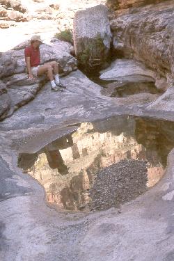
At the base of the tree trunk, a small exposed ledge with sloping walls and a few scrubby pines offers a bit of security -- and fabulous Indian petroglyphs on several levels. The rangers in the Park's backcountry office had never seen these petroglyphs. Harvey Butchart, 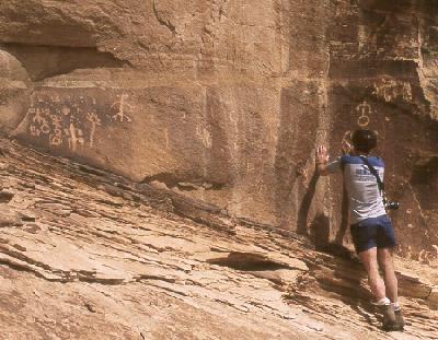 a renowned canyon explorer who was probably the second non-Native American down this route in the late 1970s, called this "the most interesting way through the Coconino" in the Canyon. a renowned canyon explorer who was probably the second non-Native American down this route in the late 1970s, called this "the most interesting way through the Coconino" in the Canyon.
From this point, the route to the top of the rappel was "relatively" easy -- easy for Terry and Ted, pretty scary for the rest of us in the strong wind. It was fortunate that this rappel was about 70 feet, as that was the length of the rope we had. From a distance, it seemed a vertical face, but it probably sloped at about 70 degrees, with one 6-foot ledge on it and some minor assistance from prehistoric Anasazi-carved toeholds. 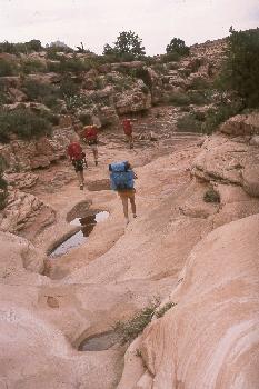 We continued down a few more switchbacks until, secure on unexposed slopes, we made our way downhill to Royal Arch Creek and a very enjoyable creek-bottom walk to our first camp, where we found nice water pools for cooking and drinking and loud chicken frogs and zooming bats to lull us to sleep. We continued down a few more switchbacks until, secure on unexposed slopes, we made our way downhill to Royal Arch Creek and a very enjoyable creek-bottom walk to our first camp, where we found nice water pools for cooking and drinking and loud chicken frogs and zooming bats to lull us to sleep.
The rest of the trip we never saw a cloud. Hot days and cool nights were the rule. The second day, we continued down Royal Arch Creek. The mostly-dry drainage goes to the Colorado River, but sheer 100-foot-plus cliffs with no way around forced the route to ascend a steep face to a point above the east side of the creek bed. We walked here for about a half-mile on a decent trail, but one which was 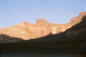 anywhere from one to five feet from perilous, sheer vertical drops of 400 feet or more. anywhere from one to five feet from perilous, sheer vertical drops of 400 feet or more.
I for one was petrified all along this stretch, eyes focussed on the two feet of trail immediately ahead, taking baby steps the whole way. Lynda and Bill weren't too happy either. This path gave a new meaning to the word "exposure" -- you are literally exposed for many minutes to the possibility of falling to your death! Passing through, in spite of the gut-wrenching fear, was among the hardest things I've ever done. You feel pretty good (not just relieved) after accomplishing something like that.
Finally reaching an open section, we relaxed on the trail for a while, but the only way off this flat, plateau-like area is a 30-foot rappel on a near-vertical face. We had to be belayed both above and below the rappel itself -- and the wind was still blowing. Trust in Terry and Ted and in the security of the ropes got us through. The rocks were travertine, deposits from springs which had flowed out from the Redwall Limestone, and travertine weathers to a very sharp, scalloped texture -- not something you want to put your hands or clothes on (it's called "tearpants weathering" and it lived up to its name), but we had little choice. A clear trail, used by river boat travellers, descended several hundred feet to beaches on the Colorado River at the mouth of a draw -- our second camp, on very comfortable sand.
 Fairly easy hiking among the boulders and rocks one or two hundred feet above the river (Do not visualize a pleasant stroll along the beach! The beaches are very local.) led us to Garnet Canyon, where we camped virtually on the unconformity between the Precambrian rocks and the Cambrian Tapeats Sandstone. Pools were present, but they proved to be undrinkably alkaline even with purification tablets and kool-aid flavoring, so Ted and Terry hiked to the river for water. Ted and I also went up the canyon perhaps a mile, past many pools and scalloped basins in the ledge-forming Tapeats. It is a fine side canyon to explore. Fairly easy hiking among the boulders and rocks one or two hundred feet above the river (Do not visualize a pleasant stroll along the beach! The beaches are very local.) led us to Garnet Canyon, where we camped virtually on the unconformity between the Precambrian rocks and the Cambrian Tapeats Sandstone. Pools were present, but they proved to be undrinkably alkaline even with purification tablets and kool-aid flavoring, so Ted and Terry hiked to the river for water. Ted and I also went up the canyon perhaps a mile, past many pools and scalloped basins in the ledge-forming Tapeats. It is a fine side canyon to explore.
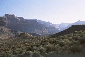
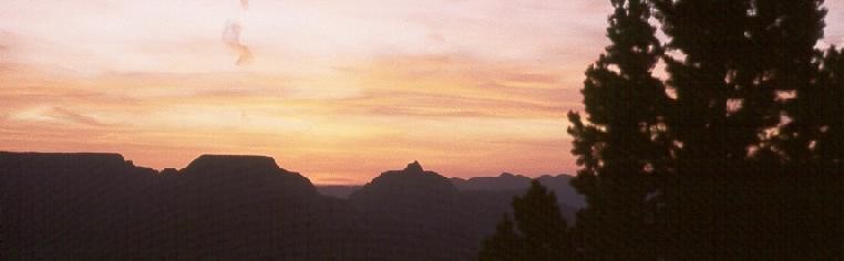
 Our camp was at the western terminus of the Tonto Trail, in this area a route which contours around the south side of the river on the Tonto Platform, a relatively level expanse cut in the non-resistant Bright Angel Shale. It parallels the river, 1200 feet or so above it, with considerable undulation and occasional short stretches of scary exposure, and magnificent views of the canyon itself, from the river to (sometimes) the rims. Our camp was at the western terminus of the Tonto Trail, in this area a route which contours around the south side of the river on the Tonto Platform, a relatively level expanse cut in the non-resistant Bright Angel Shale. It parallels the river, 1200 feet or so above it, with considerable undulation and occasional short stretches of scary exposure, and magnificent views of the canyon itself, from the river to (sometimes) the rims.
This day, temperatures exceeded 97°F in the sun, which is where we usually were. Much of the nearly 8-mile walk was in "jungles" of black bush, a knee-high shrub (sometimes waist-high) with sharp stems which radiate all over. It's not a cactus (which are usually avoidable), but it sure can rip skin. Lynda won the "bloodiest legs" contest but we were all pretty scarred up.
 Copper Canyon develops out of Evolution Amphitheatre, and near an overhung Tapeats shelf not far from the dry creek bed, we camped on an Indian mescal pit. Actually a mound, these piles of rocks were probably used by the Indians as ovens to roast agave (century plants) which they ate. There were many animal bones in the pile as well -- almost like a midden. Another mescal pit was visible down the canyon. These are among the most common archeological remains in the Grand Canyon. Copper Canyon develops out of Evolution Amphitheatre, and near an overhung Tapeats shelf not far from the dry creek bed, we camped on an Indian mescal pit. Actually a mound, these piles of rocks were probably used by the Indians as ovens to roast agave (century plants) which they ate. There were many animal bones in the pile as well -- almost like a midden. Another mescal pit was visible down the canyon. These are among the most common archeological remains in the Grand Canyon.
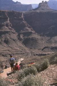
Along the open and hot Tonto Trail, we skirted Wallace Butte and Tyndall Dome en route to Bass Canyon. We saw people travelling by dory camped on the river far below near Shinumo Rapids, the only people we saw on the entire trip. We reached Bass Trail by diverse routes and camped about two miles up-trail from the river. The trail in Bass Canyon is a "civilized" one, though it is still listed as secondary and not regularly maintained. 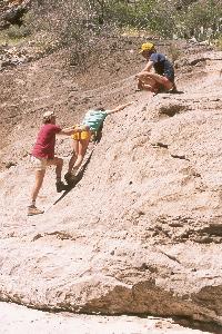 As it was very hot and dry, Ted, Bill, and I undertook a 4-mile round trip hike to the river for water (Ted and Bill did all the work). The good trail passes through excellent exposures of black, white, and pink sedimentary rocks, part of the late Precambrian Unkar Group. These rocks were folded and faulted more than 700 million years ago, and the faults were later rejuvenated to form the weak zone which localized Bass Canyon. At the refreshing river, we found the metal boat abandoned by the Russell-Quist expedition in 1914. The Park Service has now anchored it to the rock. As it was very hot and dry, Ted, Bill, and I undertook a 4-mile round trip hike to the river for water (Ted and Bill did all the work). The good trail passes through excellent exposures of black, white, and pink sedimentary rocks, part of the late Precambrian Unkar Group. These rocks were folded and faulted more than 700 million years ago, and the faults were later rejuvenated to form the weak zone which localized Bass Canyon. At the refreshing river, we found the metal boat abandoned by the Russell-Quist expedition in 1914. The Park Service has now anchored it to the rock.
 The Bass Trail from our camp switchbacked up through surprisingly heavy vegetation in the Redwall Limestone, traversable here by virtue of the Bass Canyon Fault Zone, and on to a half-mile exposed traverse in the Supai Formation. Typical tight switchbacks took us to the top of the Coconino Sandstone, and soon after that to the rim. It is a great trail, somewhat demanding physically and a little moreso in terms of the fear factor, but compared to what we had already been through, it was a breeze. The Bass Trail from our camp switchbacked up through surprisingly heavy vegetation in the Redwall Limestone, traversable here by virtue of the Bass Canyon Fault Zone, and on to a half-mile exposed traverse in the Supai Formation. Typical tight switchbacks took us to the top of the Coconino Sandstone, and soon after that to the rim. It is a great trail, somewhat demanding physically and a little moreso in terms of the fear factor, but compared to what we had already been through, it was a breeze.
We left our camp in Bass Canyon (at 3300 feet) before dawn in order to avoid the heat of the day, and were at the rim (6700 feet) in 5˝ hours. Ted and Bill had raced ahead to get the truck, parked four miles away at the abandoned Pasture Wash Ranger Station. We drove back to Grand Canyon Village, where we enjoyed our first beer immediately -- in the parking lot, in the back of the pick-up.
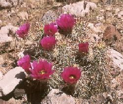 Spring was very evident throughout the 35 miles of the hike. Most plants, except barrel cacti and a few others, were at least partially in flower, from the painful black bush (not black at all, with yellow flowers, green leaves, and gray stick stems) to the brilliant purple-red of the Opuntia and Engelmann cacti. Red penstemons, sunflowers, asters, and the white, funnelform flowers of the hallucinogenic sacred datura were present, along with redbuds and other flowering trees (such as catclaw, another skin-ripper). Spring was very evident throughout the 35 miles of the hike. Most plants, except barrel cacti and a few others, were at least partially in flower, from the painful black bush (not black at all, with yellow flowers, green leaves, and gray stick stems) to the brilliant purple-red of the Opuntia and Engelmann cacti. Red penstemons, sunflowers, asters, and the white, funnelform flowers of the hallucinogenic sacred datura were present, along with redbuds and other flowering trees (such as catclaw, another skin-ripper).
Among shrubs, you learn with alacrity that the jointed Mormon tea will not scratch, while the black bush will, and you walk the trail accordingly. The tips of live agave fronds are penetratingly sharp and very painful, but tree yuccas have flexible leaves which can be pushed aside.
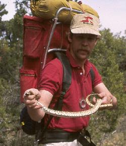 Collared lizards, scaly lizards, spiny lizards and skinks were common. We saw a large bull snake on the rim, and fat chuckwallas were encountered occasionally. At one lunch stop, a big chuckwalla Terry had startled earlier came directly toward us across forty feet of rock and soil, as if on the attack. It passed within inches of us and scattered rocks from the overhanging cliff where we sat in the shade. Bill had an aversion to critters. One night, therefore, it was only appropriate that his sleeping bag was in the path of the nocturnal migration of a bunch of toads -- they traversed him, landing on his forehead and generally having a good time. Collared lizards, scaly lizards, spiny lizards and skinks were common. We saw a large bull snake on the rim, and fat chuckwallas were encountered occasionally. At one lunch stop, a big chuckwalla Terry had startled earlier came directly toward us across forty feet of rock and soil, as if on the attack. It passed within inches of us and scattered rocks from the overhanging cliff where we sat in the shade. Bill had an aversion to critters. One night, therefore, it was only appropriate that his sleeping bag was in the path of the nocturnal migration of a bunch of toads -- they traversed him, landing on his forehead and generally having a good time.
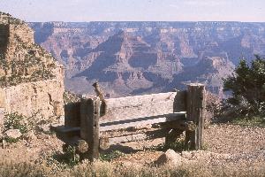 Back in South Rim Village, the fear and hard work of the trip seemed a lot more pleasurable in retrospect. Possibly fewer than 50 people have descended the Point Huitzil Route in modern times, and Lynda is probably the first non-Native American woman to traverse it. This remarkable adventure tested our physical limits and challenged my threshhold of fear. The canyon is amazing, especially from below the rim, with the nearest other people miles and days away, in striking contrast to the congested view most people obtain from the village, where the song of the tour bus drowns out the plaintive call of the canyon wren. Back in South Rim Village, the fear and hard work of the trip seemed a lot more pleasurable in retrospect. Possibly fewer than 50 people have descended the Point Huitzil Route in modern times, and Lynda is probably the first non-Native American woman to traverse it. This remarkable adventure tested our physical limits and challenged my threshhold of fear. The canyon is amazing, especially from below the rim, with the nearest other people miles and days away, in striking contrast to the congested view most people obtain from the village, where the song of the tour bus drowns out the plaintive call of the canyon wren.
"Now I see the secret of making the best persons,
it is to grow in the open air
and to eat and sleep
with the earth."
--- Walt Whitman, Leaves of Grass 
©1987-2000 Richard I. Gibson
Back to Expeditions Page
|