Geology of Boulder Flatirons
The Fountain Formation
by Dick Gibson

Back to Geology Of.....
Back to Jefferson County Open Spaces

 The Fountain Formation is a sandstone of Pennsylvanian age that crops out along the Front Range in Colorado. It forms the Flatirons west of Boulder as well as the Red Rocks near Morrison and the Garden of the Gods near Colorado Springs. Most of the Fountain Formation can be called an arkose, a coarse, feldspar-rich sandstone that is typically pink in color because of the abundant pink feldspar grains within it. It was deposited by alluvial fans and braided steams draining off a nearby mountain uplift, part of the Ancestral Rockies. Much of Central Colorado was uplifted during this mountain-building event, which occurred about 230 million years before the modern Rockies were raised. The Fountain Formation was deposited about 290-296 million years ago.
In some parts of the Fountain Formation you can easily see the channels and cross-beds (small dune-like forms) that indicate deposition by streams. Although most of the grains (both pink feldspar and buff to white quartz) are coarse sand size (around 2 mm and sometimes larger), you should be able to find extremely coarse individual clasts. Feldspar crystals an inch or more long may show perfectly flat cleavage (breakage) faces.
Most of the pink color comes from feldspar, but in some zones a dark purplish color is probably imparted by hematite (iron oxide) cement. The Fountain Formation is pretty crumbly, which indicates that it is not very well cemented. Together with its coarse grain size, this is evidence for a deposit that was laid down very near the source area. Further evidence for this is the presence of feldspar, which is unstable relative to quartz. In mature sandstones that have been transported great distances, most of the feldspar has weathered to clay and is gone, leaving only clean quartz in environments like beaches.
Even more evidence for the proximity of the source of the Fountain sediments is the fact that in most areas of the Front Range, these rocks lie directly upon 1.7-billion-year-old Precambrian rocks. The surface between the Precambrian rocks and the Fountain Formation is called an unconformity, and it represents a time break of neary one and one-half billion years for which there is no rock record. If any rocks were deposited during this interval, they were eroded during the uplift of the Ancestral Rockies.
Sand and gravel from the Fountain Formation is the primary constituent of the ice-abatement material that Colorado Departments of Transportation put on snowy roads in the Front Range area. When one of these rocks chips your windshield, at least now you know a bit about its history! 
 For more technical information on the Fountain Formation, a good starting point is the Rocky Mountain Association of Geologists' Geologic Atlas of the Rocky Mountain Region, the Big Red book published in 1972. See especially papers by Mallory on the Pennsylvanian strata (p. 131).
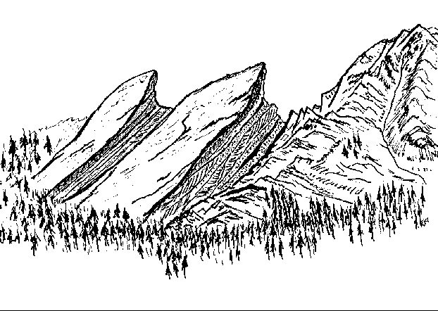
Drawn by Dick Gibson